Campus Wayfinding Solution for High-Volume Public Safety Net Hospital
San Francisco, CA
This confidential client is a high-volume public safety net hospital and trauma center that provides inpatient, outpatient, emergency, skilled nursing, diagnostic, mental health and rehabilitation services for adults and children. The campus serves a diverse population that includes a wide range of user needs across mobility, sensory, cognitive, cultural, socio-economic, language, literacy, and acuity. Originally built in the late 1800’s, the expansive campus now has 13 buildings and continues to grow and change. Our research team and design partner are currently in year two of a multi-year research and design process.
The Challenge
How do you create a “radically inclusive” wayfinding system? The client identified the extreme difficulty in navigating their campus had become a barrier to optimal patient service. To improve wayfinding and signage, the client sought to develop a comprehensive and integrated wayfinding scheme to support current and future building renovations and additions on campus, as well as construction disruptions and department and clinic relocations. Ultimately, the wayfinding plan must help patients and visitors find their intended hospital location. The wayfinding design needed to be inspirational and reflective of the client’s values and brand, and specifically address digital strategy, room signage, directional signage, campus and building identification, and multilingual needs and regulatory compliance.
The Process
Boulder Associates Architects’ research team provided pre-design research services to the project Signage Consultant. We conducted an analysis of the current campus wayfinding deficiencies to provide design recommendations for an equitable and intuitive wayfinding solution.
We embraced a person-centered strategy employing methods across user experience, evidence-based design and lean processes, to make use of a robust evidence-base, maximize efficiencies, yet recognize that each person’s healthcare journey is unique.
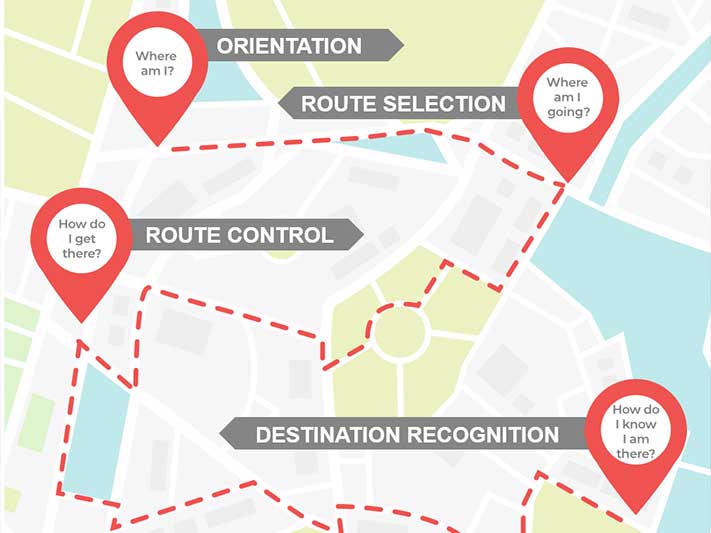
Our research roadmap was derived from the field of spatial cognition to understand how our brain creates a map of space, calculates routes, and recognizes distinct places. Some of our research activities included studying:
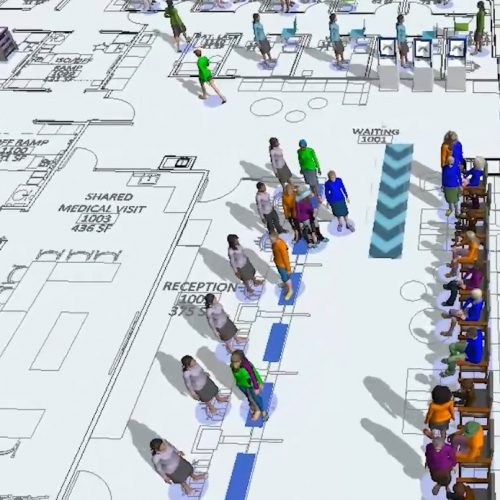
- How can we increase access, walking efficiency and wayfinding through strategic grouping of clinical departments, and improving access to those centralized locations? We studied arrival and destination points across campus and performed a building analysis showing daily user volumes over time to inform circulation modelling supporting a current and future network of paths.
- How can we capture the experiences of diverse campus users, and develop wayfinding solutions which meet their needs? We conducted patient walkalongs to identify campus wayfinding challenges experienced by diverse users across various settings. We captured our findings by creating representative personas and journeys which we later used to test design solutions.
Our research findings yielded data to inform user wayfinding experience beyond wayfinding graphics and signage. Thus, we delivered recommendations for infrastructure improvements such as renovating campus and building entrances to optimize accessibility, and process improvements such as pre-appointment coordination with arrival location, and staff training.
Campus zoning, building identification and saliency testing. Results collected from interviews with campus users (staff, patients, and visitors) across languages suggested that many users experience confusion about where buildings are located due to the absence of any over-arching district or networked path organization, and the non-sequential order of numbered buildings. The team provided recommendations for district and building integrated identification schemes to replace or supplement the current non-salient, non-sequential building numbered schemes including:
- Define zones based on campus arrival point and associated circulation path
- Replace non-sequential building numbering with sequential numbering
- Enhance zone identity with theme, color and texture
- Enhance building identify with symbol, theme, color and texture
Route control through circulation modeling. Based on future state building volume projections, the team proposed to design additional campus access points and paths, a “Main Street” path, and a central campus hub. The team is currently in the process of developing and testing design solutions using pedestrian simulation technology to appropriately size and locate campus entries/exits, and create efficiencies by evaluating additional paths and access points, and alternative vehicular drop off locations for staff and emergency.
The Results
Campus zoning, building identification and saliency testing. Future state scenario planning determined that circulation paths and campus access points will likely change in the future. Thus, groups of buildings were assigned to zones associated with programmatic use. Zones were defined using different brand identity colors.
Due to cost, the client decided they could not replace their historic building numbering scheme. Thus, it became even more critical to enhance building saliency through other cues including zone color, and symbol where applicable (such as “H” for Hospital). Specific thematic and textural concepts are currently being evaluated with patient groups using VR simulations and focus groups.
The client’s decision to centralize clinical outpatient services, will reduce average patient walking distances by half. We are evaluating potential efficiencies gained from other proposed new and renovated circulation options. The wayfinding plan overall is projected to decrease staff-assisted wayfinding instances resulting in a significant savings in staff time.
Lessons Learned
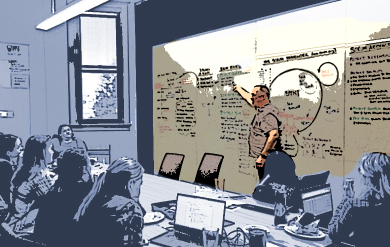
To effectively manage the sheer number and complexity of wayfinding recommendations, the team created a pull planning workshop to develop an implementation schedule for wayfinding improvements. Campus, building and technological wayfinding solutions will continue to be refined and implemented over the next three years. While the system is in the process of planning the implementation of the solutions, the exercise has already informed and educated the administration on the importance of using research and analysis to create environments that cater to patients from broad, dissimilar, backgrounds.
It was an eye-opening lesson to many that in the absence of a wayfinding program, acute patients have lost precious time wandering instead of receiving care, and staff were spending often more than 30 minutes per shift escorting users to their destinations.
Administrators learned wayfinding is a necessity, not an amenity, to providing care.